Isaac Oelgart introduces us to his Baron J.J. Forrester’s Historic Map of the Douro Project. This project has taken one of the most famous Douro maps and created a collector's item for Port fans everywhere.
THE BARON J.J. FORRESTER MAP PROJECT
© ISAAC OELGART – 12/06
ISAAC’S PORT PASSION IN HIS OWN WORDS
My first bottle of Vintage Port was in 1972. I was 24 years old. It was a 1955 Graham’s, which I must add was quite good. The company was great, the food was great, the wine with the meal was great. The Port wine after the meal was even greater. It was so good that for the next 34 years I pursued as many different Vintage Ports as I could - too many to list and like children much too hard to pick a favorite.
Becoming as fond of Port as I did and being a rare book dealer at the time and being of an inquisitive nature inclined to history, a lover of books and collector by temperament, it was quite natural for me to begin collecting books, pamphlets and all matter of material related to the literature, history, production, distributaries and enjoyment of Vinho do Porto. I will confess that as time went by when forced to choose between buying a rare bottle of wine or a rare book I would buy the book. Reading a rare Port book accompanied with a glass of excellent Port in hand is a pleasure second only to sharing a bottle of Port with your lover.
It was my interest in the history of Port that led me to Joseph James Forrester, who in my opinion is the single most important man in the history of Port. That he was a winemaker, a scientist, an artist, an ethnographer, a pioneer photographer and sometimes “pain in the ass” to his fellow wine makers; it was his interest in the Douro and skill as a cartographer that really capture my deep interest, respect and admiration for him.
Thus it was about six years ago it occurred to me that a fitting tribute to Forrester would be to reproduce his 10 foot map of the Douro and his smaller map of the Douro’s Wine District with an accompanying text volume and to house the book and the maps in a large 28” x 20” clam shell box.
The “big” map, the map of The Douro River, is exceedingly rare, original copies are almost never offered for sale. No one knows for sure exactly how many maps were produced, likely no more than 100. They may show up on the market - about one every 10 years or so and they’re getting scarcer and extraordinarily expensive. While it might still be possible to find one in some British antique shop for a song, anyone who knows what it is, knows it worth at least $10,000 and could bring much more at auction.
The “small” map, the map of the wine district, is much more common having been reproduced in at least 5 different editions of Forrester’s books. Still an original of the small map is worth $1,000 to $2,000 depending on the condition and state.
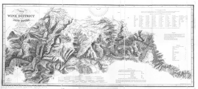
Baron Forrester Map of the Wine District of the Alto Douro
Having deemed in my own mind that the maps were worthy of reproduction, it occurred to me that there should be an accompanying text and who better than Richard Mayson, noted and highly regarded author on Port, to write the text. When I approached him about the project he accepted without equivocation. I asked Debbie Hall of the British Library Map room to lend her hand in a form of a cartographer’s essay. Personally, I could not resist adding my two cents in the from of a very brief essay on Forrester: The Delineator.
Having moved from rare book dealing to fine book making in the early 1980’s I thought that such a project as I envisioned it was possible and marketable. However, I had no idea how difficult it would be to capture Baron Forrester’s 10 foot image.
My first thought was to just photograph it in 3 pieces. Due to the size and loss of detail, that proved it was not feasible. Then I tried taking 1:1 ratio photographs, 10 inches x 10 inches and creating offset film, which also proved unacceptable. Through much painstaking experimentation, I found that digitizing the image was the best way to simultaneously capture detail and color balancing.
My first attempt to have the image digitized was with a scanner, however no scanners were large enough to accept the entire 10’ image and I was not about to cut up an original to accommodate a drum scanner. Scanning on a flat bed scanner and tiling the pieces didn’t work out well enough either. The next step was to test a digital camera at The Stinehour Press in Lunenburg, Vermont. Stinehour is world renowned for their quality and ability to attack difficult printing jobs. At that time Stinehour spent about a year, off and on, trying to capture the image and found this to be a great challenge. The file was so big that it crashed their computers and Photoshop software. Computers and programs are now more equipped to handle a job of size - but this now and that was then.
I even tried a large format scanner which looks at a one inch wide, by up to 48 inches tall area and can make a continuous long scan, memory allowing. That too, failed. Determined to succeed, I continued my quest to bring this project to fruition.
As digital camera technology grew in capability to handle huge files, hope loomed, but too much detail from the soft engraving was lost or weak. Long exposure times were required and having a steady hand and stable environment was essential. Additionally, the lighting could not fluctuate as that threw off the critical color balance. After a few more experiments, the camera was mounted to the ceiling, the map laid flat on a table, a power stabilizer was added to the lighting and on a Saturday morning with the rest of the crew off and all other equipment turned off, suitable images were finally captured.
Once I had a digital file of the entire map, I had Stinehour separate the files into three pieces to fit their 40” x 28” press, Four of the six sides (three 40” x 28” sets of plates have six lengthwise sides) of the images overlapped so when cut, they could be joined in a seamless image.
The rest of the project was much less complicated. Portfolio Box of Rhode Island made the clamshell boxes to my exacting specification. The text volume was printed by The Leahy Press of Montpelier, Vermont and my friends at New Hampshire Bindery in Concord, NH did the binding for the text volume. The gold foil printing for the box label, the map wrapper label and the text volume was done on a glossy black paper, reminiscent of the 1850’s.
The large, almost 10 foot long map has been scored and accordion folded to accommodate easy viewing (up to 40 inches at a glance). The small map is scored once and folded in half. I maintain the photographic portrait of Baron Forrester, which served as the frontispiece of the text volume, (as was the original it was taken from) foxing and all. I wanted the map to look old and for the most part, that was not retouched. After more than five years, all the parts came together quite well.
EXCLUSIVE OFFER TO ROY’S FTLOP GANG
Only 200, numbered and initialed sets will be for sale at $950.00 per set, which includes custom made shipping crates. Additional cost of insurance and Priority shipping within the continental USA equal approximately $50.00.
I am willing to ship to any friend of For The Love Of Port, whether in the USA or across the globe. Shipping costs can range from $100.00 to $240.00 depending on world wide destination.
For those desiring maps more suited for framing, rolled versions are available for an additional $100.00 post paid. The rolled maps will not be sold separately and are in addition to one of the numbered sets.
Personal checks, drawn on US banks and in US dollars, are fine and I will NOT wait for checks to clear. International money orders drawn on US banks will be accepted as well as US dollars, shipped via registered mail. I also accept Paypal as my only credit card option.
If for any reason you wish to return the set, you may do so within seven days of receipt (you pay the cost of return shipping and insurance) for a full refund.
(this offer now closed)
Leave A Comment
You must be logged in to post a comment.