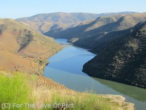
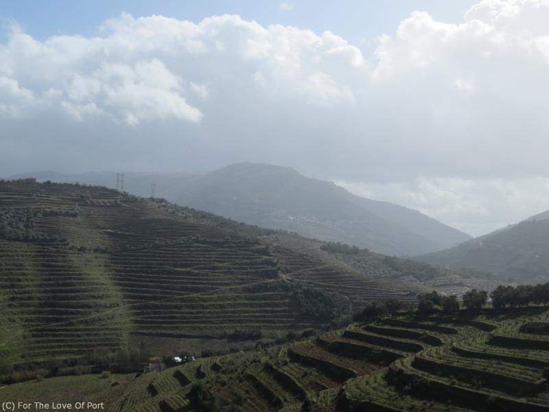
10:40 am in November, low sun throws deep shadows across mountains in the Douro Superior
Talking about the weather is an ideal ice-breaker – but talking about weather in the Douro really does make for interesting conversation, and not just to those who love Port. While most areas lay claim to the saying “If you don’t like the weather wait ten minutes” the Douro must be unique in that if you don’t like the weather, you can just walk 200 metres down hill, or over that ridge to your left into the next valley.
To understand the weather, an understanding of the geography is fundamental. If you are not familiar with the area, or want to brush up a bit, let's start with:
Douro Geography Basics
The Douro runs pretty well east to west, from the frontier with Spain to Porto, about 142 km / 88 miles as the crow flies and about 210 km / 130 miles if you follow the windings of the river itself. From Porto roughly 60 km to the east (37 miles) is the start of the demarcated wine region which corresponds with the line of the Serra do Marão, a chain of mountains that runs from the river northwards, dividing the Minho along the coast from the Trâs-os-Montes (literally Behind-the-Mountains) region.
On the map below look for Vila Real – the palest patches of colour in that zone indicate 1000 to 2000 metres of altitude – the backbone of the Marão. The palest green is 500 to 1000 metres, the mid green 200 to 500 metres, and the few tiny patches of darker green along the river (which is covered by the yellow dotted line to indicate the division between districts) indicate 50 to 200 metres of altitude.
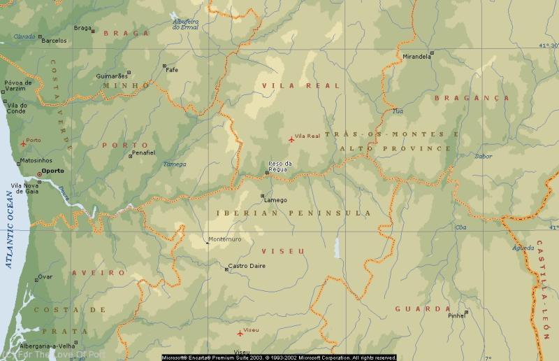
The Baixo Corgo extends from the Marão to just east of Régua – figure roughly at the end of the word “da” in “Peso da Régua” on the map. Continuing east, you can see the line of the Tua River which is concurrent with the line between Vila Real and Bragança districts just north of the Douro River. Follow the yellow dotted line of the Douro south east from there and you see a tiny speck of deeper green on the south bank of the river, below the P in Province – that is roughly the location of the Valeira Dam which divides the Cima Corgo from the Douro Superior which extends from there to the frontier with Spain.
What the map does not begin to convey is the convolutions of the terrain in the Baixo and Cima Corgo. To get an idea, crumple up a piece of paper and then stop and look at it – at all the high points of crumples and the gorges between, all twisted and criss-crossing one another. That is what the landscape is like in these zones. East of the Valeira Dam the landscape continues mountainous, but is more open, not so tightly crumpled, and as you get out towards Vilariça, north of the Douro at the far eastern end, it is gently rolling and even nearly level in places between hills which are not as sharply vertical as they are elsewhere.
Because of this mountainous, crumpled terrain, the micro-climatisation is intense, and some viticulturists go so far as to claim that each vine has its own unique micro-climate. But even stepping back a bit to look across a quinta, or even a large parcel within a quinta, there will be differences because of altitude, because of exposure to rainfall or the run-off, and because of the exposure to sun, both the sheer hours of exposure and the time of day when that occurs. Six hours of sunlight in the cool early morning on an east facing slope is a very different thing from six hours towards the end of the day with full western or southern exposure when the temperatures for the day are probably at their peak.
Going back to the analogy of that crumpled up ball of paper - think about the shadows thrown between all the crumples. I have been in fundamentally north facing vineyards in winter, when the sun is low in the sky and much of the lower altitude ground receives no sun and holds a bit of frost or ice all day. And yet, at the top of the hills or in a break in a valley the sunlight can make it warm enough not just to melt the frost but to invite you to leave your jacket off. To me, the things that most clearly express the micro-climatisation are first, watching the pattern of sunlight and shadow across the hills changing over the course of the day and the second is at harvest when I am tasting the grapes and finding the flavour profiles and intensity of flavour vastly different from one end of a row of vines to the other, or just a few rows apart.
Douro Weather Patterns – An Overview
When it rains on the coast at Porto, generally the storms sweep inland and eastward. We get soaked here and all the way to the line of the Marão, which together with the area just east of the mountains, the Baixo Corgo, also usually gets a pretty comprehensive soaking. What happens after that depends on the force of the storm. It may peter out there or continue eastward, generally losing force as it goes. As a result, typical annual rainfalls across the region are around 1200 mm rain on the coast at Porto and similar at Vila Real in the Marão. The Baixo Corgo sub-region of the Douro receives a bit less, perhaps 900 mm. In the Cima Corgo they typically get half of what doused the coast – 600 to 700 mm – and in the Douro Superior maybe 25 to 30% of the coastal rainfall – 400 mm per year on average.
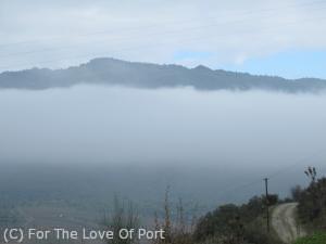
A layer of cloud around 250-300 metres of altitude
But it gets much more complex than that due to the landscape contours. The Symingtons are fond of pointing out that whereas Dow’s Quinta do Bomfim on the river at Pinhão has an average annual rainfall of 772 mm, Warre’s Quinta da Cavadinha just a few kilometres north but at a higher altitude has an annual average of 1,065 mm. Runoff from the higher elevations of course affects the "rainfall" effect and fertility in lower lying areas. Rainfall on the two sides of the river can be different by several millimetres – and that is enough to make a difference to the vines.
In the winter it is not uncommon for clouds to settle at around 300 to 400 metres of altitude, leaving the river quintas in the gloom while the altos, the higher ground, are in brilliant sunshine and looking down on a layer of thick white cloud.
Rainfall in the Douro
Let's look a little more closely at rainfall patterns, since drought has been the overriding consideration the past few years across the region.
Note that the viticultural year begins in November (and when I speak of years here, I will be referring to the viticultural, not calendar years), after the harvest when the vines are going dormant for the winter. Many viticulturists, particularly those focussed on organic or bio-dynamic regimes, feel that the conditions and care of the vine over the winter set the stage for the rest of the growing season. It is similar to how getting a really good or bad night’s sleep determines how well you can get through the next day – it doesn’t look as if you are doing anything, sleeping, but actually, that period of rest is critical to your health and well being for the next 24 hours at least!
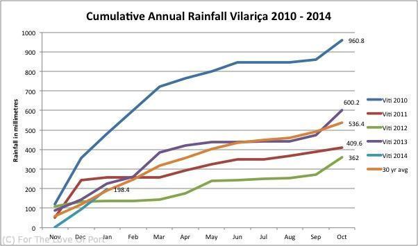
The first chart shows the monthly rainfall in Vilariça, in the north-eastern part of the Douro Superior from 2010 through January 2014. In the middle of the graph, the gold coloured line is the the 30 year average rainfall figure.
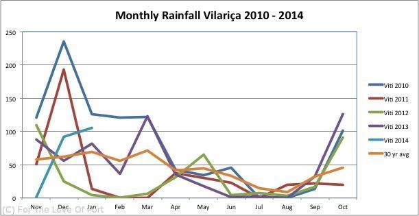
You can see quite clearly from the spikes that most of the annual rainfall, and the heaviest rains, fall during the Nov-Dec-Jan-Feb timeframe. The uppermost blue line is for the 2010 season, when 723.6 mm of rain fell from November 2009 to March 2010. This is almost 35% more than Vilariça typically gets in a year (the 30 year average total is 536.4 mm) and accounted for 75% of the rainfall that year. June, July and August are the low points for rainfall and every winemaker prays for a bit of rain, but not too much, in late August or early September to help in the final ripening of the grapes ahead of harvest. As you can see, they usually do get a little something at that time, and then the rain can begin again in earnest in October.
The second graph charts the cumulative rainfall for those same years with the 30 year average again in gold, mid graph. 2010 was truly soggy – 960.8 mm vs that 30 year average of 536.4. But then 2011 (in rusty red) was below average, 2012 (green) further below average, and 2013 recovered to average rainfalls levels, thankfully. The 2014 year is off to a respectable start: though we had not one drop of rain in November, December gave us 91.8 mm in Vilariça, 105.6 in January, and though official figures are not yet available for February I was told on the 11th of February they had already had 96 mm.
This winter rainfall, following on a decent year for rain in 2013, has made the viticulturists I have spoken to cautiously optimistic for the 2014 season. One also remarked that the vines had held their leaves late into the autumn which is a good sign, and is anticipating a good year with good production.
The downside of the heavy winter rains of course can be delays in the winter work. My sources have mostly been able to progress the pruning not too far off schedule, but landscaping or new vineyard planting and set-up projects have been delayed, and in some cases there is repair work to be done: one friend commented in February that on the drive from Pinhão up to Sabrosa or towards Favaios or Alijo a bit further east he saw a lot of damage to terraces, both stone walls that had crumbled and fallen and earthen patamares that had eroded badly and would need repair, once the rains had eased off so the tractors could work again. Earlier this week I was visiting a quinta situated on the south side of the river between Régua and Pinhão and just before we left the caseiro told us the road to Pinhão had just been closed, due to a landslide across the road.
So, whatever you read about the weather in the Douro – realise it is either a broad generalisation or possibly a uniquely local phenomenon which may or may not affect your favourite quinta or producer. For this reason, I am looking forward not only to bringing you routine updates on weather patterns generally for the region, but regular visits to producers to learn how the season is playing out uniquely at their own properties. The first of those visits, as mentioned, occurred earlier this week, look for that report shortly.
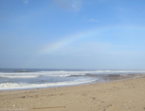
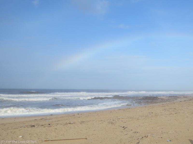
While we enjoy full sun someone to the south is getting a good drenching

Thanks for a really interesting report Cynthia and I look forward to the next blog about the visit to the quinta.
Hi Alex, thanks for your kind words and visiting us here!
[…] ADVID, the Douro viticultural research agency whose statistics I used in my Weather in the Douro update, have not yet published the February statistics. So, whilst I cannot provide numbers and […]